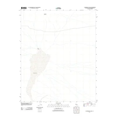
2012 Map of Cuddeback Lake
USGS Topo · Published 2012About this map
Cuddeback Lake dominates this arid landscape in San Bernardino County, appearing as a broad dry bed that defines the basin's floor. To the north, the terrain rises toward Almond Mountain, a prominent landform overlooking the northern reaches of the lake and the transitional Almond Cove. The map reveals a high-desert environment where drainage patterns are primarily ephemeral, dictated by the topographic relief of the surrounding hills. This 2012 survey serves as a modern baseline for the region, documenting the minimal human infrastructure and primitive roads that navigate the open spaces between these geological landmarks.
Find a feature on this map
3 named features on this map. Tap any name to fly to it.
Don’t see what you’re looking for? This feature index may not catch every label — zoom into the map to look around manually.
Map Details
Editions of this 2012 Cuddeback Lake Map
This is the sole edition of this map. No revisions or reprints were ever made.
Other maps of this area

1903 · Randsburg
USGS Topo · 1:62,500

1911 · Randsburg
USGS Topo · 1:62,500

1912 · Randsburg
USGS Topo · 1:62,500

1915 · Searles Lake
USGS Topo · 1:250,000

1947 · Trona
USGS Topo · 1:250,000

1948 · Trona
USGS Topo · 1:250,000

1953 · Trona
USGS Topo · 1:250,000
1954 · Boron
USGS Topo · 1:62,500

1954 · Cuddeback Lake
USGS Topo · 1:62,500

1956 · Fremont Peak
USGS Topo · 1:62,500