
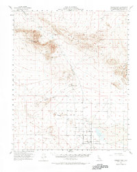
1956 Map of Fremont Peak
USGS Topo · Published 1957About this map
Mining operations and arid land management define this mid-century survey of the Mojave landscape, conducted during the administration of Governor Goodwin J. Knight. The prominent Fremont Peak stands as a central landmark, surrounded by evidence of extraction such as the Monarch-Rand Mine and several unnamed shafts and prospects. Near the northern boundary, the Res Hamburger Mill (Site) marks the location of former industrial activity, while the presence of Petroglyphs near Black Mtn indicates much older human passage through these canyons.
Find a feature on this map
31 named features on this map. Tap any name to fly to it.
Don’t see what you’re looking for? This feature index may not catch every label — zoom into the map to look around manually.
Map Details
Editions of this 1956 Fremont Peak Map
2 editions found
Other maps of this area

1903 · Randsburg
USGS Topo · 1:62,500

1911 · Randsburg
USGS Topo · 1:62,500

1912 · Randsburg
USGS Topo · 1:62,500

1915 · Searles Lake
USGS Topo · 1:250,000

1932 · Barstow
USGS Topo · 1:125,000

1934 · Barstow
USGS Topo · 1:125,000

1937 · Kramer
USGS Topo · 1:48,000

1942 · Kramer
USGS Topo · 1:62,500

1947 · Kramer
USGS Topo · 1:24,000

1947 · Johannesburg SE
USGS Topo · 1:25,000