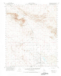
1956 Map of Fremont Peak
USGS Topo · Published 1970About this map
Fremont Peak dominates the landscape of this high desert region in San Bernardino County, where mid-century mapping efforts recorded a sparse but significant industrial and archaeological history. The northern terrain is defined by the Gravel Hills and the dry basins of Cuddeback Lake and Dry Lake, connected by the winding Hoffman Road. Resource extraction is evident through the presence of the Monarch Rand Mine and various Shafts and Tunnels scattered across the peaks. A notable historical marker is the Res Hamburger Mill (Site), suggesting earlier pioneer-era processing facilities. To the south, the settlement at Lockhart sits near the edge of Harper Lake, an area marked by extensive Sand Dunes and agricultural infrastructure like the McDonald Well. Of significant cultural interest is the label for Petroglyphs near Black Mtn, indicating the long-standing indigenous presence in the Mojave prior to modern ranching and mining.
Find a feature on this map
29 named features on this map. Tap any name to fly to it.
Don’t see what you’re looking for? This feature index may not catch every label — zoom into the map to look around manually.
Map Details
Editions of this 1956 Fremont Peak Map
2 editions found

Other maps of this area

1903 · Randsburg
USGS Topo · 1:62,500

1911 · Randsburg
USGS Topo · 1:62,500

1912 · Randsburg
USGS Topo · 1:62,500

1915 · Searles Lake
USGS Topo · 1:250,000

1932 · Barstow
USGS Topo · 1:125,000

1934 · Barstow
USGS Topo · 1:125,000

1937 · Kramer
USGS Topo · 1:48,000

1942 · Kramer
USGS Topo · 1:62,500

1947 · Kramer
USGS Topo · 1:24,000

1947 · Johannesburg SE
USGS Topo · 1:25,000