
1947 Map of Kramer
USGS Topo · Published 1947About this map
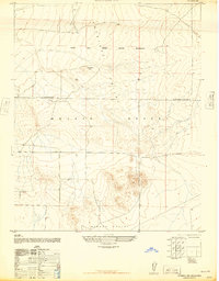
The Mojave Desert terrain dominates this mid-century survey, defined by the expansive Muroc Army Airfield Military Reservation and its network of mountain-peak vantage points. Several Observation towers are positioned throughout the southern half of the sheet, reflecting the high-desert landscape's role in post-war military operations. Near the northern boundary, the Atchison Topeka and Santa Fe railroad serves as the primary transportation artery, anchoring small desert outposts. The settlement of Kramer and the road junction at Beechers Corners provide the few hubs of human activity in an otherwise austere landscape of basins and ridgelines. The transition from civilian railroad corridor to restricted military airspace captures a specific moment in the evolution of San Bernardino County's desert geography just after the war.
Find a feature on this map
8 named features on this map. Tap any name to fly to it.
Don’t see what you’re looking for? This feature index may not catch every label — zoom into the map to look around manually.
Map Details
Editions of this 1947 Kramer Map
This is the sole edition of this map. No revisions or reprints were ever made.
Other maps of this area

1915 · Searles Lake
USGS Topo · 1:250,000

1932 · Barstow
USGS Topo · 1:125,000

1934 · Barstow
USGS Topo · 1:125,000

1937 · Kramer
USGS Topo · 1:48,000

1942 · Kramer
USGS Topo · 1:62,500

1947 · Johannesburg SE
USGS Topo · 1:25,000

1947 · Rich
USGS Topo · 1:24,000

1947 · Red Buttes
USGS Topo · 1:24,000

1947 · Johannesburg SW
USGS Topo · 1:24,000
1947 · Kramer SW
USGS Topo · 1:24,000