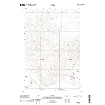
2020 Map of Culbertson
USGS Topo · Published 2020About this map
Culbertson serves as the primary hub on this northeastern Montana landscape, situated north of the Missouri River where it meets the southern boundary of the Fort Peck Indian Reservation. The map shows a transition from the river valley into the uplands, marked by the confluence of Big Muddy Creek and Clover Cr. The settlement of Blair is visible to the west along the rail corridor. Local history and genealogy are preserved at Hillside Cem on the outskirts of Culbertson and Bauer Cem located to the west. This 2020 survey documents the modern layout of the town, including its grid from 1st St E up to 7th St E, alongside the operational aviation footprint of Big Sky Field. The terrain is defined by drainage patterns like Scott Cr cutting through the northern townships of t29n r55e.
Find a feature on this map
31 named features on this map. Tap any name to fly to it.
Don’t see what you’re looking for? This feature index may not catch every label — zoom into the map to look around manually.
Map Details
Editions of this 2020 Culbertson Map
This is the sole edition of this map. No revisions or reprints were ever made.
Other maps of this area

1914 · Homestead
USGS Topo · 1:62,500

1947 · Rocky Point
USGS Topo · 1:24,000

1948 · Rocky Point
USGS Topo · 1:24,000

1948 · Fort Kipp
USGS Topo · 1:24,000

1949 · Fort Kipp
USGS Topo · 1:24,000

1949 · Johnson Lake
USGS Topo · 1:24,000
1950 · Johnson Lake
USGS Topo · 1:24,000

1954 · Wolf Point
USGS Topo · 1:250,000

1958 · Wolf Point
USGS Topo · 1:250,000
1969 · Culbertson
USGS Topo · 1:24,000
Featured Places
- Culbertson, MT
- Fort Kipp District, MT
- Averill, Culbertson
- Walker Mobile Home Park, Culbertson
- Roosevelt County, MT