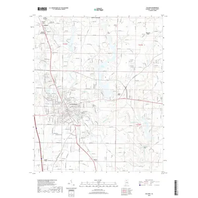
2018 Map of Cullman
USGS Topo · Published 2018About this map
The city of Cullman serves as the central hub of this North Alabama landscape, situated atop the Brindley Mountain plateau. The terrain is defined by the Tennessee Valley Divide, where water begins its descent toward different regional drainage basins. The CSX Transportation rail line bisects the city, anchoring a corridor of historical development that stretches from Vinemont in the north through Phelan and Good Hope to the south. Significant water features like the expansive Lake Catoma and Sportman Lake contrast with the rugged creek valleys of Eightmile Creek and Brindley Creek. Numerous local burying grounds, including Saint Bernard Abbey Cem and Sacred Heart Cem, reflect the area's deep-rooted community history and religious heritage along the Eightmile Creek watershed.
Find a feature on this map
269 named features on this map. Tap any name to fly to it.
Don’t see what you’re looking for? This feature index may not catch every label — zoom into the map to look around manually.
Map Details
Editions of this 2018 Cullman Map
This is the sole edition of this map. No revisions or reprints were ever made.
Other maps of this area

1888 · Cullman
USGS Topo · 1:125,000

1892 · Cullman
USGS Topo · 1:125,000

1927 · Falkville
USGS Topo · 1:24,000

1936 · Eva
USGS Topo · 1:24,000

1936 · Lawrence Cove
USGS Topo · 1:24,000

1949 · Falkville
USGS Topo · 1:24,000
1949 · Lawrence Cove
USGS Topo · 1:24,000
1949 · Eva
USGS Topo · 1:24,000
1951 · Lawrence Cove
USGS Topo · 1:24,000
1951 · Eva
USGS Topo · 1:24,000