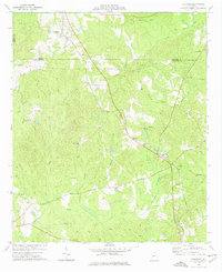
1974 Map of Culloden
USGS Topo · Published 1976About this map
Culloden and Musella anchor this rural landscape where Monroe, Crawford, and Upson counties meet. The mid-1970s terrain is marked by a complex network of waterways, including Echeconnee Creek and Uleohatchee Creek, alongside several family cemeteries such as Feagin Cem and Taylor Cem. A distinctive landmark is the City of Refuge (Sanatorium) located near a small Landing Field. Transportation infrastructure is a central theme, defined by the active Southern railroad line cutting diagonally across the land, contrasted with an Old Railroad Grade to the northeast. The presence of multiple pipelines and pumping stations indicates the mid-century industrial utility of this Piedmont region, while rural spiritual life is documented at New Lebanon Ch and Mt Carmel Ch.
Find a feature on this map
37 named features on this map. Tap any name to fly to it.
Don’t see what you’re looking for? This feature index may not catch every label — zoom into the map to look around manually.
Map Details
Editions of this 1974 Culloden Map
This is the sole edition of this map. No revisions or reprints were ever made.
Other maps of this area

1951 · Yatesville
USGS Topo · 1:62,500

1955 · Phenix City
USGS Topo · 1:250,000

1956 · Fort Valley
USGS Topo · 1:62,500

1956 · Bolingbroke
USGS Topo · 1:62,500

1957 · Phenix City
USGS Topo · 1:250,000

1957 · Macon
USGS Topo · 1:250,000

1958 · Macon
USGS Topo · 1:250,000

1958 · Phenix City
USGS Topo · 1:250,000

1964 · Macon
USGS Topo · 1:250,000

1971 · Fickling Mill
USGS Topo · 1:24,000