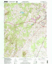
1997 Map of Culpeper West
USGS Topo · Published 1999About this map
The western outskirts of Culpeper and the rural Piedmont landscape define this late-twentieth-century survey. Large water bodies like Lake Pelham and Mountain Run Lake dominate the northern terrain, providing clear markers for the expansion of local infrastructure near the Filtration Plant. Further south, the map transitions into a network of established crossroads and smaller settlements, including White Shop, Merrimac, and Winston. The presence of the Southern railroad line and the Madison Co Culpeper Co boundary line provide important geographic context for researchers tracing local development.
Find a feature on this map
43 named features on this map. Tap any name to fly to it.
Don’t see what you’re looking for? This feature index may not catch every label — zoom into the map to look around manually.
Map Details
Editions of this 1997 Culpeper West Map
This is the sole edition of this map. No revisions or reprints were ever made.
Other maps of this area

1887 · Spottsylvania
USGS Topo · 1:125,000

1892 · Spottsylvania
USGS Topo · 1:125,000

1892 · Gordonsville
USGS Topo · 1:125,000

1893 · Luray
USGS Topo · 1:125,000

1894 · Warrenton
USGS Topo · 1:125,000

1894 · Warrenton
USGS Topo · 1:62,500

1905 · Luray
USGS Topo · 1:125,000

1927 · Remington
USGS Topo · 1:48,000

1930 · Warrenton
USGS Topo · 1:62,500

1943 · Culpeper
USGS Topo · 1:24,000