
1943 Map of Culvers Gap
USGS Topo · Published 1943About this map
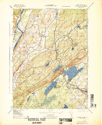
The Delaware River carves a path through the northwest corner of this terrain, where the historic Dingmans Ferry crossing and Delaware Cemetery reflect generations of riverside life. Moving east, the landscape transitions from the river valley into the prominent Kittatinny Mountains, featuring the strategic Culvers Gap and the surrounding wilderness of Stokes State Forest. This 1940s survey reveals a dispersed network of rural communities, including Peters Valley, Bevans, and Layton, often centered around landmarks like the Sandyston School. Local industry and recreation are evident in features such as the Snooks Lumber Mill and the Madeleine Mulford Girl Scout Camp near Stony Lake. The presence of several Usc&GS survey markers and the Normanock Lookout Tower underscores the importance of this high-elevation ridge for regional mapping and observation during the mid-twentieth century.
Find a feature on this map
58 named features on this map. Tap any name to fly to it.
Don’t see what you’re looking for? This feature index may not catch every label — zoom into the map to look around manually.
Map Details
Editions of this 1943 Culvers Gap Map
2 editions found
Other maps of this area

1888 · Franklin
USGS Topo · 1:62,500

1891 · Wallpack
USGS Topo · 1:62,500

1893 · Wallpack
USGS Topo · 1:62,500

1894 · Franklin
USGS Topo · 1:62,500

1897 · Franklin
USGS Topo · 1:62,500

1903 · Franklin Furnace
USGS Topo · 1:62,500

1906 · Port Jervis
USGS Topo · 1:62,500

1908 · Port Jervis
USGS Topo · 1:62,500

1913 · Milford
USGS Topo · 1:62,500

1915 · Milford
USGS Topo · 1:62,500
Featured Places
- Hampton Township, NJ
- Stillwater Township, NJ
- Montague Township, NJ
- Branchville, NJ
- Sandyston Township, NJ