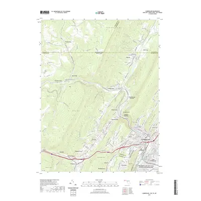
2019 Map of Cumberland
USGS Topo · Published 2019About this map
Cumberland sits at a critical geographic nexus where the North Branch Potomac River meets Wills Creek, serving as a gateway through the Appalachian ridges. This modern survey illustrates the dense infrastructure required to navigate this corridor, featuring the Brush Tunnel and Knobly Tunnel, alongside the legacy of the Chesapeake and Ohio Canal National Historical Park. The landscape is defined by steep ridges like Haystack Mtn and Shriver Ridge, which have historically funneled transportation through the narrow gap known as The Narrows. This topography created a concentrated network of rail junctions including Mount Savage Junction and Eckhart Junction. Beyond the industrial center, the map details numerous smaller communities such as Ellerslie, Corriganville, and La Vale, while preserving the locations of local landmarks like Saint Patricks Cem and Rose Hill Cem, which offer significant value for genealogical research in this long-settled river valley.
Find a feature on this map
164 named features on this map. Tap any name to fly to it.
Don’t see what you’re looking for? This feature index may not catch every label — zoom into the map to look around manually.
Map Details
Editions of this 2019 Cumberland Map
This is the sole edition of this map. No revisions or reprints were ever made.
Other maps of this area

1898 · Frostburg
USGS Topo · 1:62,500

1899 · Flintstone
USGS Topo · 1:62,500

1900 · Flintstone
USGS Topo · 1:62,500

1901 · Frostburg
USGS Topo · 1:62,500

1908 · Frostburg
USGS Topo · 1:62,500

1923 · Berlin
USGS Topo · 1:48,000

1927 · Hyndman
USGS Topo · 1:62,500

1929 · Berlin
USGS Topo · 1:62,500

1931 · Hyndman
USGS Topo · 1:62,500

1944 · Hyndman
USGS Topo · 1:62,500