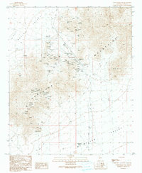
1990 Map of Cunningham Pass
USGS Topo · Published 1990About this map
The Harcuvar Mountains dominate this 1990 provisional survey, acting as a high divide between the broad Butler Valley to the northwest and McMullen Valley to the southeast. This desert landscape is characterized by a high density of mining activity concentrated around Cunningham Pass. Named operations such as the Little Giant Mine, Critic Mine, and Columbia Mine are clustered near the mountain's crest, supported by a network of unimproved roads and four-wheel-drive trails.
Find a feature on this map
30 named features on this map. Tap any name to fly to it.
Don’t see what you’re looking for? This feature index may not catch every label — zoom into the map to look around manually.
Map Details
Editions of this 1990 Cunningham Pass Map
This is the sole edition of this map. No revisions or reprints were ever made.
Other maps of this area

1923 · Signal
USGS Topo · 1:250,000

1942 · Signal
USGS Topo · 1:250,000

1942 · Vicksburg
USGS Topo · 1:250,000

1950 · Prescott
USGS Topo · 1:250,000

1954 · Prescott
USGS Topo · 1:250,000

1954 · Phoenix
USGS Topo · 1:250,000

1957 · Phoenix
USGS Topo · 1:250,000

1958 · Prescott
USGS Topo · 1:250,000

1958 · Phoenix
USGS Topo · 1:250,000

1959 · Prescott
USGS Topo · 1:250,000