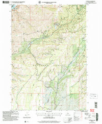
2004 Map of Cuprum
USGS Topo · Published 2007About this map
Cuprum and the settlement at Bear anchor this section of the Payette National Forest during a period of modern forest management and remote habitation. The landscape is defined by the steep descent toward the Snake River and Hells Canyon Reservoir, where the border between Wallowa and Adams Counties follows the waterway. Evidence of the region’s mining heritage is prominent, with the Copper Cliff Mine, a Mine Shaft, and numerous other prospects scattered across the high terrain.
Find a feature on this map
35 named features on this map. Tap any name to fly to it.
Don’t see what you’re looking for? This feature index may not catch every label — zoom into the map to look around manually.
Map Details
Editions of this 2004 Cuprum Map
This is the sole edition of this map. No revisions or reprints were ever made.
Other maps of this area

1920 · Seven Devils Mining District
USGS Topo · 1:48,000

1955 · Baker
USGS Topo · 1:250,000

1955 · Grangeville
USGS Topo · 1:250,000

1957 · Cuprum
USGS Topo · 1:62,500

1957 · Homestead
USGS Topo · 1:62,500

1957 · Copperfield
USGS Topo · 1:62,500

1957 · Hornet
USGS Topo · 1:62,500

1959 · Baker
USGS Topo · 1:250,000

1959 · Grangeville
USGS Topo · 1:250,000

1980 · McCall
USGS Topo · 1:100,000