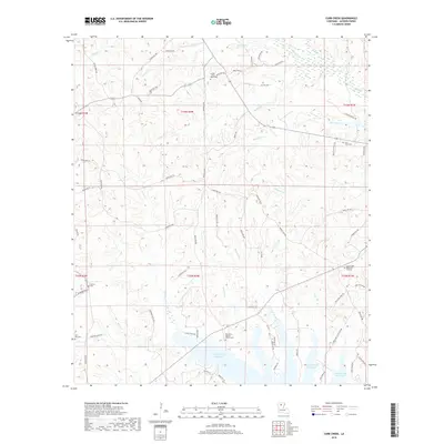
2018 Map of Curr Creek
USGS Topo · Published 2018About this map
Caney Creek Reservoir dominates the southern landscape of this Jackson Parish region, reflecting the engineered hydrology that defines modern northern Louisiana. The terrain is characterized by a dense network of drainages including Curr Creek, Fourmile Cr, and Cypress Cr, which carve through the wooded hills. For family historians, the sheet is particularly valuable for its documentation of local burial grounds and spiritual centers. Places like the Ebenezer Baptist Church Cem, Collier / New Hope Cem, and Saint Clair Cem are preserved here alongside established parish routes like Mary West Rd and Winnfield Rd. The map illustrates the transition from traditional rural homesteads to the recreational and residential development surrounding the reservoir shoreline.
Find a feature on this map
73 named features on this map. Tap any name to fly to it.
Don’t see what you’re looking for? This feature index may not catch every label — zoom into the map to look around manually.
Map Details
Editions of this 2018 Curr Creek Map
This is the sole edition of this map. No revisions or reprints were ever made.
Other maps of this area

1949 · Jonesboro
USGS Topo · 1:62,500

1950 · Jonesboro
USGS Topo · 1:62,500

1953 · Chatham
USGS Topo · 1:62,500

1953 · Hodge
USGS Topo · 1:62,500

1954 · Sikes
USGS Topo · 1:62,500

1955 · Shreveport
USGS Topo · 1:250,000

1956 · Shreveport
USGS Topo · 1:250,000

1982 · Chatham
USGS Topo · 1:24,000
1982 · Eros
USGS Topo · 1:24,000

1984 · Shreveport
USGS Topo · 1:250,000