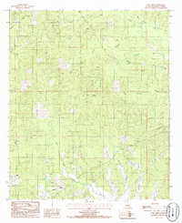
1985 Map of Curr Creek
USGS Topo · Published 1986About this map
Curr Creek and its many tributaries, including White Branch and Poplar Branch, define the topography of this section of Jackson Parish during the mid-1980s. The landscape is characterized by a dense network of drainages and timbered ridges, where human activity is marked by utility infrastructure rather than concentrated settlements. Significant industrial corridors are visible through a Wooden Pole Transmission Line and several Pipe Line or Pipeline routes that traverse the terrain. Local landmarks of interest include a Lookout Tower positioned for fire monitoring and a small Cem located near Fourmile Creek. This provisional survey captures the transition of rural Louisiana as it was managed for both natural resources and regional utility distribution, providing a clear record of the watershed and rural road network before modern development.
Find a feature on this map
16 named features on this map. Tap any name to fly to it.
Don’t see what you’re looking for? This feature index may not catch every label — zoom into the map to look around manually.
Map Details
Editions of this 1985 Curr Creek Map
This is the sole edition of this map. No revisions or reprints were ever made.
Other maps of this area

1949 · Jonesboro
USGS Topo · 1:62,500

1950 · Jonesboro
USGS Topo · 1:62,500

1953 · Chatham
USGS Topo · 1:62,500

1953 · Hodge
USGS Topo · 1:62,500

1954 · Sikes
USGS Topo · 1:62,500

1955 · Shreveport
USGS Topo · 1:250,000

1956 · Shreveport
USGS Topo · 1:250,000

1982 · Chatham
USGS Topo · 1:24,000
1982 · Eros
USGS Topo · 1:24,000

1984 · Shreveport
USGS Topo · 1:250,000