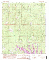
1994 Map of Curr Creek
USGS Topo · Published 1995About this map
Caney Creek Reservoir dominates the southern landscape of this Louisiana parish, where its irregular, purple-shaded shoreline indicates significant mapping updates in the mid-1990s. This drainage network, characterized by slow-moving waterways like Castor Creek and Fourmile Creek, reflects the low-lying, riparian character of Jackson Parish. The presence of Caney Creek Lake State Park along the southeastern shore marks the transition of the area toward public recreation and conservation.
Find a feature on this map
17 named features on this map. Tap any name to fly to it.
Don’t see what you’re looking for? This feature index may not catch every label — zoom into the map to look around manually.
Map Details
Editions of this 1994 Curr Creek Map
This is the sole edition of this map. No revisions or reprints were ever made.
Other maps of this area

1949 · Jonesboro
USGS Topo · 1:62,500

1950 · Jonesboro
USGS Topo · 1:62,500

1953 · Chatham
USGS Topo · 1:62,500

1953 · Hodge
USGS Topo · 1:62,500

1954 · Sikes
USGS Topo · 1:62,500

1955 · Shreveport
USGS Topo · 1:250,000

1956 · Shreveport
USGS Topo · 1:250,000

1982 · Chatham
USGS Topo · 1:24,000
1982 · Eros
USGS Topo · 1:24,000

1984 · Shreveport
USGS Topo · 1:250,000