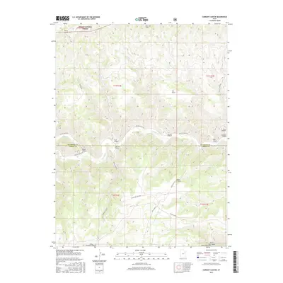
2017 Map of Currant Canyon
USGS Topo · Published 2017About this map
The Stone Cabin Gas Field sits at the heart of this high-desert landscape where the border of Duchesne Co and Carbon Co crosses deep canyons. The terrain is defined by the sharp transition from the West Tavaputs Plateau to the carved drainage systems of Nine Mile Cr. To the north, the Bad Land Cliffs rise near the southern boundary of the Ashley National Forest, while the southeast is marked by the branching systems of Ninemile Canyon and Prickly Pear Canyon. This survey illustrates the intricate network of resource-extraction infrastructure and historic access routes, such as Stone Cabin Trl and Prickly Pear Rd, that navigate the complex topography of Argyle Canyon and Currant Canyon.
Find a feature on this map
26 named features on this map. Tap any name to fly to it.
Don’t see what you’re looking for? This feature index may not catch every label — zoom into the map to look around manually.
Map Details
Editions of this 2017 Currant Canyon Map
This is the sole edition of this map. No revisions or reprints were ever made.
Other maps of this area

1886 · Price River
USGS Topo · 1:250,000

1896 · Price River
USGS Topo · 1:250,000

1915 · Sunnyside
USGS Topo · 1:62,500

1954 · Flat Canyon
USGS Topo · 1:62,500

1956 · Price
USGS Topo · 1:250,000

1960 · Price
USGS Topo · 1:250,000

1962 · Price
USGS Topo · 1:250,000
1968 · Anthro Mtn NE
USGS Topo · 1:24,000

1968 · Wood Canyon
USGS Topo · 1:24,000
1968 · Cowboy Bench
USGS Topo · 1:24,000