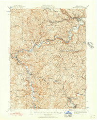
1939 Map of Curwensville
USGS Topo · Published 1956About this map
West Branch Susquehanna River and Clearfield Creek anchor this detailed study of central Clearfield County, following a landscape defined by the Pennsylvania and New York Central railroads. The map documents a dense network of early 20th-century rural infrastructure, from the timber-driven settlement of Lumber City to the coal-region outposts of Coalport and Irvona. Genealogists will find a wealth of family and community landmarks, including numerous rural schoolhouses like Ferguson Sch and Oakland Sch, and historic burial sites such as Friends Cem and Watts Cem.
Find a feature on this map
114 named features on this map. Tap any name to fly to it.
Don’t see what you’re looking for? This feature index may not catch every label — zoom into the map to look around manually.
Map Details
Editions of this 1939 Curwensville Map
2 editions found

Other maps of this area

1902 · Patton
USGS Topo · 1:62,500

1902 · Barnesboro
USGS Topo · 1:62,500

1903 · Curwensville
USGS Topo · 1:62,500

1903 · Houtzdale
USGS Topo · 1:62,500

1904 · Barnesboro
USGS Topo · 1:62,500

1904 · Patton
USGS Topo · 1:62,500

1905 · Houtzdale
USGS Topo · 1:62,500

1906 · Punxsutawney
USGS Topo · 1:62,500

1920 · Altoona
USGS Topo · 1:62,500

1922 · Altoona
USGS Topo · 1:62,500