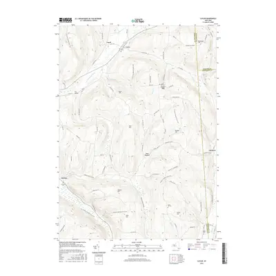
2016 Map of Cuyler
USGS Topo · Published 2016About this map
Cuyler and the surrounding high ground of the Cortland and Madison County border area are defined by a complex network of ridges and narrow stream valleys. The East Branch Tioughnioga River and its tributaries, including Cheningo Creek and Maxon Creek, carve through the terrain, creating a landscape where small hamlets like Tripoli and Cheningo were established at key road intersections and water gaps. This topography necessitated a winding transportation network, including the North Country National Scenic Trail, which traverses the southern portion of the quadrangle.
Find a feature on this map
75 named features on this map. Tap any name to fly to it.
Don’t see what you’re looking for? This feature index may not catch every label — zoom into the map to look around manually.
Map Details
Editions of this 2016 Cuyler Map
This is the sole edition of this map. No revisions or reprints were ever made.
Other maps of this area

1897 · Cazenovia
USGS Topo · 1:62,500

1899 · Cazenovia
USGS Topo · 1:62,500

1900 · Tully
USGS Topo · 1:62,500

1903 · Cortland
USGS Topo · 1:62,500

1904 · Pitcher
USGS Topo · 1:62,500
1943 · Tully
USGS Topo · 1:24,000

1943 · De Ruyter
USGS Topo · 1:24,000

1943 · South Ostelic
USGS Topo · 1:24,000

1943 · Cincinnatus
USGS Topo · 1:24,000
1943 · Erieville
USGS Topo · 1:24,000