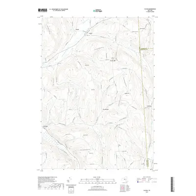
2019 Map of Cuyler
USGS Topo · Published 2019About this map
Cuyler sits at the junction of the E Br Tioughnioga River and Tioughnioga Cr, anchoring a landscape defined by its high ridges and narrow valley settlements. The terrain is marked by significant elevations like Bull Hill and Randall Hill, which separate the river valleys from the upland plateaus. This 2019 survey documents a network of rural hamlets including Tripoli, New Boston, and Cheningo, each maintaining its own distinct burial grounds such as Winne Cem and Cheningo Cem. The N Country National Scenic Trail winds across the topography, crossing through the high ground of Cuyler Hill and Allen Hill. This map captures the persistent rural character of the region, where family-named landmarks like Pease Hill and Potter Hill overlook the winding courses of Maxon Cr and Cheningo Cr, reflecting generations of upland farming and land use in the hills of Central New York.
Find a feature on this map
78 named features on this map. Tap any name to fly to it.
Don’t see what you’re looking for? This feature index may not catch every label — zoom into the map to look around manually.
Map Details
Editions of this 2019 Cuyler Map
This is the sole edition of this map. No revisions or reprints were ever made.
Other maps of this area

1897 · Cazenovia
USGS Topo · 1:62,500

1899 · Cazenovia
USGS Topo · 1:62,500

1900 · Tully
USGS Topo · 1:62,500

1903 · Cortland
USGS Topo · 1:62,500

1904 · Pitcher
USGS Topo · 1:62,500
1943 · Tully
USGS Topo · 1:24,000

1943 · De Ruyter
USGS Topo · 1:24,000

1943 · South Ostelic
USGS Topo · 1:24,000

1943 · Cincinnatus
USGS Topo · 1:24,000
1943 · Erieville
USGS Topo · 1:24,000