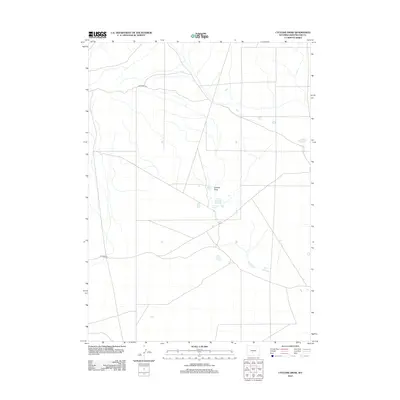
2012 Map of Cyclone Draw
USGS Topo · Published 2012About this map
Stratton Lakes dot the arid landscape of this northern section of Sweetwater County, where the terrain is defined by seasonal drainage patterns and sparse infrastructure. The eponymous Cyclone Draw cuts through the center of the sheet, serving as a primary hydrological feature in an otherwise dry high-desert environment. This 2012 survey by the U.S. Geological Survey documents a network of Bureau of Land Management routes, including BLM Road 3216 and BLM Road 3214, which provide access to this isolated interior. The map illustrates the specialized water management and access required for this region of Wyoming, where natural basins and draws dictate the movement of both water and travelers.
Find a feature on this map
5 named features on this map. Tap any name to fly to it.
Don’t see what you’re looking for? This feature index may not catch every label — zoom into the map to look around manually.
Map Details
Editions of this 2012 Cyclone Draw Map
This is the sole edition of this map. No revisions or reprints were ever made.
Other maps of this area

1955 · Lander
USGS Topo · 1:250,000

1958 · Lander
USGS Topo · 1:250,000

1960 · Five Fingers Butte
USGS Topo · 1:62,500

1960 · Lost Creek Lake
USGS Topo · 1:62,500

1961 · Lander
USGS Topo · 1:250,000
1961 · Lost Creek Reservoir
USGS Topo · 1:24,000
1961 · Olson Springs
USGS Topo · 1:24,000
1961 · Sulphur Bar Spring
USGS Topo · 1:24,000
1984 · South Pass
USGS Topo · 1:100,000
1988 · Lost Creek Lake
USGS Topo · 1:24,000