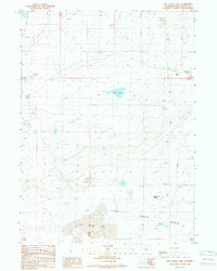
1988 Map of Lost Creek Lake
USGS Topo · Published 1989About this map
Lost Creek Lake and the broad Lost Creek Basin dominate this high desert landscape within Sweetwater County. The terrain is defined by natural depressions and springs, including Mud Lake and Mud Springs in the northern reaches, alongside the seasonal drainage of Lost Creek. Human activity is evidenced by scattered industrial and surveying marks, such as a Red Creek Well, various Gas Wells, and a solitary Prospect near the eastern boundary. The presence of Eagles Nest Spring and the distinctive Caterpillar Butte suggest specific landmarks used for navigation in this open country. This 1980s-era revision of earlier surveys provides a clear view of the hydraulic and resource infrastructure in a region defined more by its geology than by permanent settlement.
Find a feature on this map
18 named features on this map. Tap any name to fly to it.
Don’t see what you’re looking for? This feature index may not catch every label — zoom into the map to look around manually.
Map Details
Editions of this 1988 Lost Creek Lake Map
This is the sole edition of this map. No revisions or reprints were ever made.
Other maps of this area

1954 · Rock Springs
USGS Topo · 1:250,000

1955 · Lander
USGS Topo · 1:250,000

1958 · Lander
USGS Topo · 1:250,000

1958 · Rock Springs
USGS Topo · 1:250,000

1960 · Red Lake
USGS Topo · 1:62,500

1960 · Lost Creek Butte
USGS Topo · 1:62,500

1960 · Five Fingers Butte
USGS Topo · 1:62,500

1960 · Lost Creek Lake
USGS Topo · 1:62,500

1961 · Lander
USGS Topo · 1:250,000

1962 · Rock Springs
USGS Topo · 1:250,000