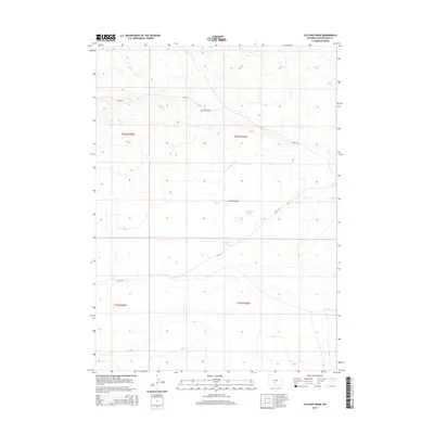
2015 Map of Cyclone Draw
USGS Topo · Published 2015About this map
Cyclone Rim dominates the upper portion of this Sweetwater County landscape, serving as a prominent topographic divide. Below this elevation, the drainage of Cyclone Draw leads toward a series of ephemeral water bodies known as the Stratton Lakes. The map reveals a high-desert environment defined by vast public lands and sparse human infrastructure, with navigation primarily dependent on Bureau of Land Management routes like BLM-3216 and BLM-3214. These roads trace the contours of the terrain, providing access through the various township and range sections such as t26n r95w and t25n r96w. The distribution of the lake beds suggests a seasonal hydrology typical of the Wyoming interior, where water collection points are as significant for wildlife and livestock as they are for surveyors.
Find a feature on this map
9 named features on this map. Tap any name to fly to it.
Don’t see what you’re looking for? This feature index may not catch every label — zoom into the map to look around manually.
Map Details
Editions of this 2015 Cyclone Draw Map
This is the sole edition of this map. No revisions or reprints were ever made.
Other maps of this area

1955 · Lander
USGS Topo · 1:250,000

1958 · Lander
USGS Topo · 1:250,000

1960 · Five Fingers Butte
USGS Topo · 1:62,500

1960 · Lost Creek Lake
USGS Topo · 1:62,500

1961 · Lander
USGS Topo · 1:250,000
1961 · Lost Creek Reservoir
USGS Topo · 1:24,000
1961 · Olson Springs
USGS Topo · 1:24,000
1961 · Sulphur Bar Spring
USGS Topo · 1:24,000
1984 · South Pass
USGS Topo · 1:100,000
1988 · Lost Creek Lake
USGS Topo · 1:24,000