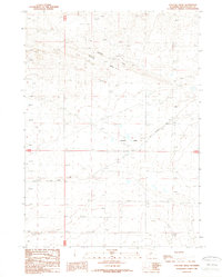
1988 Map of Cyclone Draw
USGS Topo · Published 1989About this map
Cyclone Rim defines the northern topography of this Sweetwater County landscape, creating a dramatic natural divide that funnels drainage into the eponymous Cyclone Draw. The terrain is characterized by a network of basins and depressions, most notably the Stratton Lakes in the central portion of the quadrangle. As a provisional survey reflecting field checks from the 1960s through the 1980s, the map documents a transition toward resource extraction in this high desert environment. Evidence of industrial activity is scattered across the township lines of T 26 N and T 25 N, marked by several prospects, a Gas Well, and an extensive Pipe Line network. Ground travel is limited to the Rocky Crossing Road, which provides the primary access through these sagebrush-covered basins.
Find a feature on this map
11 named features on this map. Tap any name to fly to it.
Don’t see what you’re looking for? This feature index may not catch every label — zoom into the map to look around manually.
Map Details
Editions of this 1988 Cyclone Draw Map
This is the sole edition of this map. No revisions or reprints were ever made.
Other maps of this area

1955 · Lander
USGS Topo · 1:250,000

1958 · Lander
USGS Topo · 1:250,000

1960 · Five Fingers Butte
USGS Topo · 1:62,500

1960 · Lost Creek Lake
USGS Topo · 1:62,500

1961 · Lander
USGS Topo · 1:250,000
1961 · Lost Creek Reservoir
USGS Topo · 1:24,000
1961 · Olson Springs
USGS Topo · 1:24,000
1961 · Sulphur Bar Spring
USGS Topo · 1:24,000
1984 · South Pass
USGS Topo · 1:100,000
1988 · Lost Creek Lake
USGS Topo · 1:24,000