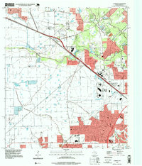
1995 Map of Cypress
USGS Topo · Published 1999About this map
Cypress Creek and its many tributaries, including Little Cypress Creek and Horsepen Creek, define this portion of Harris County as suburban expansion begins to meet older rural landmarks. This mid-1990s landscape is a study in transition, where family history sites like Graves Cem and Muller Cem sit near rapidly developing residential blocks and the Copperfield Place Shopping Ctr. The settlement of Cypress anchors the northwest, while the presence of Hot Wells and the Rodeo Ground reflect the area's long-standing community identity. Local education and aviation are central to the district's character, evidenced by the Cy-Fair High Sch and the small-scale Weiser Air Park. A dense network of infrastructure is also visible, with numerous pipelines and several sewage disposal sites supporting the area's growth toward the Houston city limits.
Find a feature on this map
35 named features on this map. Tap any name to fly to it.
Don’t see what you’re looking for? This feature index may not catch every label — zoom into the map to look around manually.
Map Details
Editions of this 1995 Cypress Map
This is the sole edition of this map. No revisions or reprints were ever made.
Other maps of this area

1915 · Cypress
USGS Topo · 1:24,000

1915 · Katy
USGS Topo · 1:24,000

1915 · Addicks
USGS Topo · 1:24,000

1915 · Hillendahl
USGS Topo · 1:24,000

1916 · Rose Hill
USGS Topo · 1:24,000

1916 · Louetta
USGS Topo · 1:24,000

1916 · Hockley
USGS Topo · 1:24,000

1916 · Satsuma
USGS Topo · 1:24,000

1916 · Swanson
USGS Topo · 1:24,000

1918 · Cypress
USGS Topo · 1:31,680