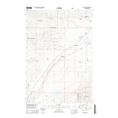
2014 Map of Dailey Lake
USGS Topo · Published 2014About this map
The Yellowstone River cuts a prominent path through this 2014 survey of Park County, Montana, serving as the central axis for the settlements of Merriman, Glastonbury, and South Glastonbury. The landscape is a study in contrasting development, where the steep, wooded slopes of the Gallatin National Forest to the west meet the valley floor's unique residential grid. North of Glastonbury, a cluster of astronomical-themed roads like Orion Way, Venus Way, and Aries Dr indicates a modern subdivided footprint nestled against the traditional ranching and mountain terrain. To the south, Dailey Lake sits near the base of the foothills, a focal point for the drainage of Sixmile Cr and Gold Prize Cr. History-minded researchers can locate the Emigrant Cem near the river, while the presence of the Yellowstone Trl S and Point of Rocks at the southern edge highlights the area's long-standing role as a corridor for travel and trade.
Find a feature on this map
56 named features on this map. Tap any name to fly to it.
Don’t see what you’re looking for? This feature index may not catch every label — zoom into the map to look around manually.
Map Details
Editions of this 2014 Dailey Lake Map
This is the sole edition of this map. No revisions or reprints were ever made.
Other maps of this area

1891 · Livingston
USGS Topo · 1:250,000

1893 · Livingston
USGS Topo · 1:250,000

1947 · Bozeman
USGS Topo · 1:250,000

1948 · Bozeman
USGS Topo · 1:250,000

1955 · Bozeman
USGS Topo · 1:250,000

1955 · Emigrant
USGS Topo · 1:62,500

1955 · Fridley Peak
USGS Topo · 1:62,500
1955 · Gardiner
USGS Topo · 1:62,500
1955 · Miner
USGS Topo · 1:62,500

1958 · Bozeman
USGS Topo · 1:250,000