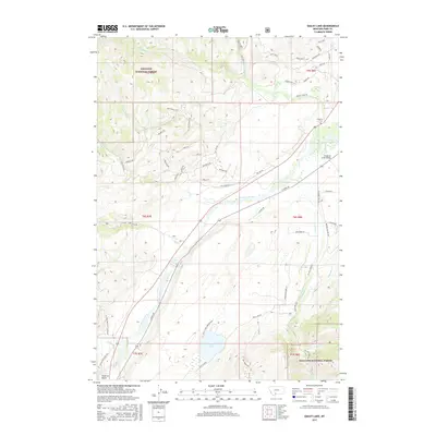
2017 Map of Dailey Lake
USGS Topo · Published 2017About this map
The Yellowstone River cuts a prominent path through this valley south of Emigrant, flanked by the high peaks of the Gallatin National Forest. The landscape is a study in contrasting terrains, from the riparian bottomlands along E River Rd to the steep elevations of Red Mountain. A unique cluster of celestial-themed roads such as Sirius Dr, Orion Way, and Polaris Way defines a residential development pattern on the northern slopes above Fridley Cr. Near the southern edge of the survey, Dailey Lake and the adjacent Dailey Lake Campground serve as a focal point for recreation. For those interested in local genealogy or early transit, the Emigrant Cem and the river crossing at Emigrant Creek Bridge offer specific points of historical continuity near the settlement of Point of Rocks.
Find a feature on this map
62 named features on this map. Tap any name to fly to it.
Don’t see what you’re looking for? This feature index may not catch every label — zoom into the map to look around manually.
Map Details
Editions of this 2017 Dailey Lake Map
This is the sole edition of this map. No revisions or reprints were ever made.
Other maps of this area

1891 · Livingston
USGS Topo · 1:250,000

1893 · Livingston
USGS Topo · 1:250,000

1947 · Bozeman
USGS Topo · 1:250,000

1948 · Bozeman
USGS Topo · 1:250,000

1955 · Bozeman
USGS Topo · 1:250,000

1955 · Emigrant
USGS Topo · 1:62,500

1955 · Fridley Peak
USGS Topo · 1:62,500
1955 · Gardiner
USGS Topo · 1:62,500
1955 · Miner
USGS Topo · 1:62,500

1958 · Bozeman
USGS Topo · 1:250,000