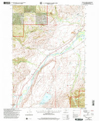
2000 Map of Dailey Lake
USGS Topo · Published 2005About this map
Paradise Valley serves as the central corridor for this mountain landscape, defined by the broad path of the Yellowstone River. The map documents the physical geography of the region as it transitioned into the 21st century, showing the intersection of agricultural land and protected wilderness. Significant portions of the terrain fall within the Gallatin National Forest and the Dome Mountain Wildlife Management Area, reflecting the area's conservation importance. Along the river valley, evidence of early settlement and rural life is preserved through labels for the Dailey (Site) and the Emigrant Cem. Smaller waterways like Fridley Creek and Eightmile Creek descend from the higher elevations to feed the main river, while Dailey Lake sits as a prominent landmark in the southern reaches of the quadrangle.
Find a feature on this map
19 named features on this map. Tap any name to fly to it.
Don’t see what you’re looking for? This feature index may not catch every label — zoom into the map to look around manually.
Map Details
Editions of this 2000 Dailey Lake Map
This is the sole edition of this map. No revisions or reprints were ever made.
Other maps of this area

1891 · Livingston
USGS Topo · 1:250,000

1893 · Livingston
USGS Topo · 1:250,000

1947 · Bozeman
USGS Topo · 1:250,000

1948 · Bozeman
USGS Topo · 1:250,000

1955 · Bozeman
USGS Topo · 1:250,000

1955 · Emigrant
USGS Topo · 1:62,500

1955 · Fridley Peak
USGS Topo · 1:62,500
1955 · Gardiner
USGS Topo · 1:62,500
1955 · Miner
USGS Topo · 1:62,500

1958 · Bozeman
USGS Topo · 1:250,000