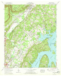
1969 Map of Daisy
USGS Topo · Published 1972About this map
The Cumberland Escarpment and the massive Walden Ridge dominate the western landscape of this 1969 survey, where the terrain drops sharply toward the burgeoning residential corridors of Hixson and Soddy-Daisy. This era captures a transition from rural industry to suburban lakeside living, illustrated by the presence of a strip mine and the Old Mill alongside newer developments like Sterling Park and Valleybrook. The eastern half of the map is defined by the broad waters of Chickamauga Lake, where Harrison Bay State Park and various marinas reflect the mid-century rise of water-based recreation. Genealogists will find a wealth of family history preserved in the numerous burial grounds scattered across the ridges, including the Jackson Chapel Cem, Smith Cem, and Foster-Hixson Cem, documenting the long-standing communities that preceded the modern expansion along the Southern RR.
Find a feature on this map
93 named features on this map. Tap any name to fly to it.
Don’t see what you’re looking for? This feature index may not catch every label — zoom into the map to look around manually.
Map Details
Editions of this 1969 Daisy Map
This is the sole edition of this map. No revisions or reprints were ever made.
Other maps of this area

1888 · Chattanooga
USGS Topo · 1:125,000

1893 · Chattanooga
USGS Topo · 1:125,000

1935 · East Chattanooga
USGS Topo · 1:24,000

1935 · Daisy
USGS Topo · 1:24,000

1935 · Soddy
USGS Topo · 1:24,000

1935 · Snow Hill
USGS Topo · 1:24,000

1935 · Ooltewah
USGS Topo · 1:24,000

1935 · Soddy Island
USGS Topo · 1:24,000

1936 · Henson Gap
USGS Topo · 1:24,000

1936 · Fairmount
USGS Topo · 1:24,000