
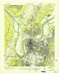
1936 Map of Fairmount
USGS Topo · Published 1936About this map
Walden Ridge and the dramatic Cumberland Escarpment define the topography of this 1936 survey, which highlights the communities atop the plateau and along the valley floor. Settlement is concentrated around Fairmount, Summertown, and the developing area of Signal Mountain, connected by a network of early mountain roads and the prominent Electric Power Transmission Line. This map, an advance sheet from the Tennessee Valley Authority and USGS, records the rural social fabric of the era through its numerous family-named landmarks and institutions.
Find a feature on this map
68 named features on this map. Tap any name to fly to it.
Don’t see what you’re looking for? This feature index may not catch every label — zoom into the map to look around manually.
Map Details
Editions of this 1936 Fairmount Map
This is the sole edition of this map. No revisions or reprints were ever made.
Other maps of this area

1888 · Chattanooga
USGS Topo · 1:125,000

1893 · Chattanooga
USGS Topo · 1:125,000

1935 · East Chattanooga
USGS Topo · 1:24,000

1935 · Daisy
USGS Topo · 1:24,000

1935 · Soddy
USGS Topo · 1:24,000

1936 · Daus
USGS Topo · 1:24,000

1936 · Henson Gap
USGS Topo · 1:24,000

1936 · Ketner Gap
USGS Topo · 1:24,000

1936 · Wauhatchie
USGS Topo · 1:24,000
1936 · Chattanooga
USGS Topo · 1:24,000