
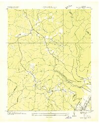
1936 Map of Henson Gap
USGS Topo · Published 1936About this map
The rugged divide of Walden Ridge dominates this 1936 survey, illustrating the sharp contrast between the deep drainage basins of the Cumberland Plateau and the fertile Sequatchie Valley. At the base of the ridge, the Sequatchie River flows parallel to the U. S. Highway No 28 (Alvin C York Highway), which serves as the primary corridor through the valley floor. Higher elevations are marked by small, remote community centers such as Lewis Chapel Sch and Davis Chapel Ch, illustrating the scattered settlement patterns of the era.
Find a feature on this map
32 named features on this map. Tap any name to fly to it.
Don’t see what you’re looking for? This feature index may not catch every label — zoom into the map to look around manually.
Map Details
Editions of this 1936 Henson Gap Map
This is the sole edition of this map. No revisions or reprints were ever made.
Other maps of this area

1888 · Chattanooga
USGS Topo · 1:125,000

1893 · Chattanooga
USGS Topo · 1:125,000

1935 · Daisy
USGS Topo · 1:24,000

1935 · Soddy
USGS Topo · 1:24,000

1935 · Brayton
USGS Topo · 1:24,000

1935 · Mount Airy
USGS Topo · 1:24,000

1936 · Daus
USGS Topo · 1:24,000

1936 · Ketner Gap
USGS Topo · 1:24,000

1936 · Fairmount
USGS Topo · 1:24,000
1936 · Savage Point
USGS Topo · 1:24,000