
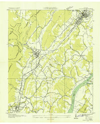
1935 Map of Soddy
USGS Topo · Published 1935About this map
Industrial activity and rural mountain life converge along the Cumberland Escarpment in this 1935 study conducted for the Tennessee Valley Authority. The landscape is defined by the steep transition from Walden Ridge down into the Tennessee River Valley, where the town of Soddy serves as a central hub. Evidence of local industry is visible through labels for a Brick Kiln, a Clay Pit, and several incline railways designed to move resources down the rugged slopes.
Find a feature on this map
48 named features on this map. Tap any name to fly to it.
Don’t see what you’re looking for? This feature index may not catch every label — zoom into the map to look around manually.
Map Details
Editions of this 1935 Soddy Map
This is the sole edition of this map. No revisions or reprints were ever made.
Other maps of this area

1888 · Chattanooga
USGS Topo · 1:125,000

1893 · Chattanooga
USGS Topo · 1:125,000

1935 · Daisy
USGS Topo · 1:24,000

1935 · Snow Hill
USGS Topo · 1:24,000

1935 · Brayton
USGS Topo · 1:24,000

1935 · Mount Airy
USGS Topo · 1:24,000

1935 · Soddy Island
USGS Topo · 1:24,000
1935 · Graysville
USGS Topo · 1:24,000

1936 · Henson Gap
USGS Topo · 1:24,000

1936 · Fairmount
USGS Topo · 1:24,000