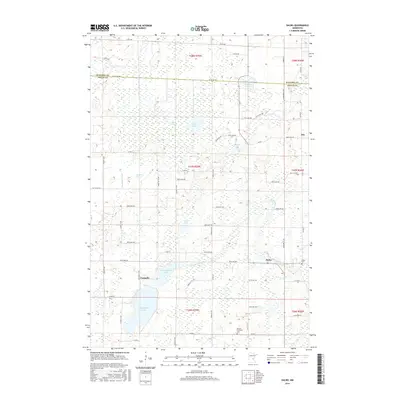
2016 Map of Dalbo
USGS Topo · Published 2016About this map
Dalbo and the surrounding wetland landscape of Isanti County are meticulously documented in this 2016 survey. The terrain is characterized by a high density of water bodies and marshy depressions, including Krone Bog, Odegard Bog, and several major lakes like N Stanchfield Lake and S Stanchfield Lake. This hydrology has clearly shaped the local road network and settlement patterns, with roads like Xenon St NW and Hematite Rd navigating between the numerous basins and the flow of Stanchfield Cr.
Find a feature on this map
62 named features on this map. Tap any name to fly to it.
Don’t see what you’re looking for? This feature index may not catch every label — zoom into the map to look around manually.
Map Details
Editions of this 2016 Dalbo Map
This is the sole edition of this map. No revisions or reprints were ever made.
Other maps of this area

1953 · Stillwater
USGS Topo · 1:250,000

1955 · Stillwater
USGS Topo · 1:250,000

1958 · Stillwater
USGS Topo · 1:250,000

1961 · Bradford
USGS Topo · 1:24,000

1961 · Springvale
USGS Topo · 1:24,000

1961 · Dalbo
USGS Topo · 1:24,000

1961 · Wyanett
USGS Topo · 1:24,000

1961 · Dalbo
USGS Topo · 1:62,500

1965 · Stillwater
USGS Topo · 1:250,000
1968 · Princeton
USGS Topo · 1:24,000