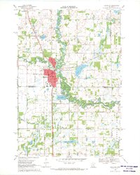
1968 Map of Princeton
USGS Topo · Published 1970About this map
The meandering Rum River serves as the central geographic feature of this late 1960s landscape, winding through Princeton and the surrounding townships. The town itself is a clear hub of activity, featuring the County Fairground, a Radio Tower, and the local Jr High Sch and High Sch. The Great Northern railroad cuts a straight north-south path through the region, passing by the small settlement of Brickton and the local Picnic Area. This survey documents a critical period of regional drainage management, shown by the extensive network of canals including County Ditch No 12 and County Ditch No 4. Genealogists will find several burial sites well-documented, from the centrally located Cemetery near the fairgrounds to the more outlying Ebenezer Cem, Berry Cem, and Baldwin Cem.
Find a feature on this map
34 named features on this map. Tap any name to fly to it.
Don’t see what you’re looking for? This feature index may not catch every label — zoom into the map to look around manually.
Map Details
Editions of this 1968 Princeton Map
2 editions found
Other maps of this area

1916 · St. Francis
USGS Topo · 1:62,500

1919 · St. Francis
USGS Topo · 1:62,500

1953 · Stillwater
USGS Topo · 1:250,000

1955 · Stillwater
USGS Topo · 1:250,000

1958 · Stillwater
USGS Topo · 1:250,000

1961 · Orrock
USGS Topo · 1:24,000

1961 · Lake Fremont
USGS Topo · 1:24,000

1961 · Dalbo
USGS Topo · 1:24,000

1961 · Wyanett
USGS Topo · 1:24,000

1961 · Elk River
USGS Topo · 1:62,500
Featured Places
- Princeton, MN
- Baldwin Township, MN
- Wyanett Township, MN
- Spencer Brook Township, MN
- Princeton Township, MN