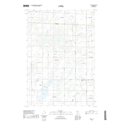
2019 Map of Dalbo
USGS Topo · Published 2019About this map
Dalbo sits at the intersection of a wetland-dominated landscape where the boundaries of Kanabec and Isanti counties meet. The area is defined by a dense network of glacial features, including Krone Lake, Lindgren Lake, and the expansive Odegard Bog. These water bodies are connected by a system of small waterways such as Stanchfield Cr and Washburn Brook, which move through the low-lying terrain. To the south, North Stanchfield Lake and South Stanchfield Lake anchor the settlement of Carmody.
Find a feature on this map
64 named features on this map. Tap any name to fly to it.
Don’t see what you’re looking for? This feature index may not catch every label — zoom into the map to look around manually.
Map Details
Editions of this 2019 Dalbo Map
This is the sole edition of this map. No revisions or reprints were ever made.
Other maps of this area

1953 · Stillwater
USGS Topo · 1:250,000

1955 · Stillwater
USGS Topo · 1:250,000

1958 · Stillwater
USGS Topo · 1:250,000

1961 · Bradford
USGS Topo · 1:24,000

1961 · Springvale
USGS Topo · 1:24,000

1961 · Dalbo
USGS Topo · 1:24,000

1961 · Wyanett
USGS Topo · 1:24,000

1961 · Dalbo
USGS Topo · 1:62,500

1965 · Stillwater
USGS Topo · 1:250,000
1968 · Princeton
USGS Topo · 1:24,000