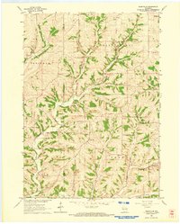
1962 Map of Daleyville
USGS Topo · Published 1964About this map
Daleyville sits at the heart of this agricultural landscape along the border of Iowa and Dane counties, where the terrain is deeply carved by the Blue Mounds Branch and German Valley Branch. This early 1960s survey documents a densely settled rural community defined by its local institutions, including numerous country schools such as Ruste Sch, Lukken Sch, and Barber Sch. The presence of the Townhall in Perry and churches like Hauge Ch suggests a well-established civic life centered around these high ridges and valleys. Evidence of local industry is visible in the scattered quarry sites that dot the hillsides, particularly near the settlement of Forward. From Indian Hill in the south to the outskirts of Mt Horeb in the north, the map provides a look at the network of township roads and property boundaries that shaped this corner of Wisconsin.
Find a feature on this map
30 named features on this map. Tap any name to fly to it.
Don’t see what you’re looking for? This feature index may not catch every label — zoom into the map to look around manually.
Map Details
Editions of this 1962 Daleyville Map
This is the sole edition of this map. No revisions or reprints were ever made.
Other maps of this area

1907 · Cross Plains
USGS Topo · 1:62,500

1909 · Cross Plains
USGS Topo · 1:62,500

1920 · Blue Mounds
USGS Topo · 1:62,500

1922 · Blue Mounds
USGS Topo · 1:62,500

1923 · Blanchardville
USGS Topo · 1:62,500

1923 · New Glarus
USGS Topo · 1:62,500

1954 · Rockford
USGS Topo · 1:250,000

1955 · Rockford
USGS Topo · 1:250,000

1957 · Madison
USGS Topo · 1:250,000

1958 · Rockford
USGS Topo · 1:250,000