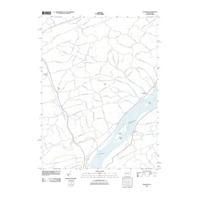
2010 Map of Dalmatia
USGS Topo · Published 2010About this map
The Susquehanna River dominates this landscape, punctuated by large fluvial features like Herrold Island, Browns Island, and Zeigler Island. In the riverside settlement of Chapman, local roads connect the community to the broader agricultural valleys. The terrain transitions into distinct geomorphic areas such as Buckwheat Valley and Trout Valley, which are drained by a complex network of waterways including Aline Creek and the North Branch Mahantango Creek.
Find a feature on this map
76 named features on this map. Tap any name to fly to it.
Don’t see what you’re looking for? This feature index may not catch every label — zoom into the map to look around manually.
Map Details
Editions of this 2010 Dalmatia Map
This is the sole edition of this map. No revisions or reprints were ever made.
Other maps of this area

1893 · Sunbury
USGS Topo · 1:62,500

1893 · Millersburg
USGS Topo · 1:62,500

1907 · Millerstown
USGS Topo · 1:62,500

1938 · Mifflinburg
USGS Topo · 1:48,000

1943 · Millerstown
USGS Topo · 1:62,500

1943 · Millersburg
USGS Topo · 1:62,500

1943 · Sunbury
USGS Topo · 1:62,500

1943 · Mifflinburg
USGS Topo · 1:62,500
1947 · Elizabethville
USGS Topo · 1:24,000
1947 · Millersburg
USGS Topo · 1:24,000