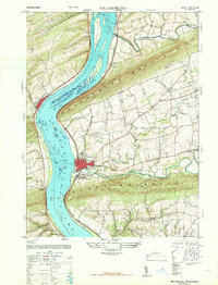
1947 Map of Millersburg
USGS Topo · Published 1947About this map
The Susquehanna River dominates this landscape, serving as a historic corridor between Mahantango Mountain to the north and Berry Mountain to the south. In 1947, Millersburg stands as the primary hub on the eastern bank, connected to the western shore by the Millersburg Ferry. This river-focused economy is further illustrated by the presence of Montgomery Ferry downstream and the sprawling Swaggerts Island and Crafts Island in the main channel. Inland, the rural character of the region is defined by a dense network of country schools and churches, including the Killinger School and New Jerusalem Church. The topography forces settlement into the narrow valleys of Mahantango Creek and Wiconisco Creek, where small hamlets like Killinger and Rife developed alongside local agricultural tracts. The Pennsylvania railroad line tracks the river's edge, highlighting the vital transportation link this valley provided for regional commerce.
Find a feature on this map
44 named features on this map. Tap any name to fly to it.
Don’t see what you’re looking for? This feature index may not catch every label — zoom into the map to look around manually.
Map Details
Editions of this 1947 Millersburg Map
2 editions found
Other maps of this area

1892 · Harrisburg
USGS Topo · 1:62,500

1893 · Millersburg
USGS Topo · 1:62,500

1899 · Harrisburg
USGS Topo · 1:62,500

1907 · New Bloomfield
USGS Topo · 1:62,500

1907 · Millerstown
USGS Topo · 1:62,500

1924 · Harrisburg
USGS Topo · 1:62,500

1943 · Millerstown
USGS Topo · 1:62,500

1943 · Millersburg
USGS Topo · 1:62,500

1943 · Harrisburg
USGS Topo · 1:62,500

1943 · New Bloomfield
USGS Topo · 1:62,500
Featured Places
- Jackson Township, PA
- Mifflin Township, PA
- Liverpool, PA
- Paxton, Upper Paxton Township
- Cloverly Acres, Upper Paxton Township