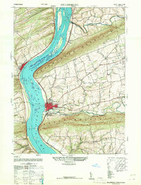
1947 Map of Millersburg
USGS Topo · Published 1968About this map
Millersburg serves as the focal point of this late 1940s landscape, situated where the broad Susquehanna River cuts through the ridges of Mahantango Mountain and Berry Mountain. The map illustrates a river-centered economy and transport network, featuring the Millersburg Ferry crossing the river toward Liverpool and the Montgomery Ferry further south. Large river features like Swaggerts Island and Grafts Island dominate the waterway, while the Pennsylvania railroad line traces the eastern bank, connecting the borough to industrial infrastructure like the local power plant.
Find a feature on this map
43 named features on this map. Tap any name to fly to it.
Don’t see what you’re looking for? This feature index may not catch every label — zoom into the map to look around manually.
Map Details
Editions of this 1947 Millersburg Map
2 editions found
Other maps of this area

1892 · Harrisburg
USGS Topo · 1:62,500

1893 · Millersburg
USGS Topo · 1:62,500

1899 · Harrisburg
USGS Topo · 1:62,500

1907 · New Bloomfield
USGS Topo · 1:62,500

1907 · Millerstown
USGS Topo · 1:62,500

1924 · Harrisburg
USGS Topo · 1:62,500

1943 · Millerstown
USGS Topo · 1:62,500

1943 · Millersburg
USGS Topo · 1:62,500

1943 · Harrisburg
USGS Topo · 1:62,500

1943 · New Bloomfield
USGS Topo · 1:62,500
Featured Places
- Jackson Township, PA
- Mifflin Township, PA
- Liverpool, PA
- Paxton, Upper Paxton Township
- Cloverly Acres, Upper Paxton Township