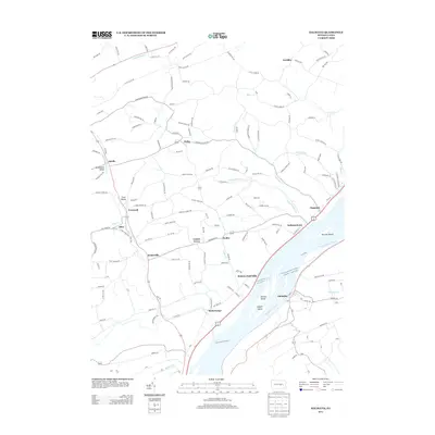
2013 Map of Dalmatia
USGS Topo · Published 2013About this map
McKees Half Falls and the surrounding riverfront communities define this stretch of the Susquehanna River valley. The landscape is characterized by a high density of small rural hamlets and named locales, including Dalmatia, Meiserville, and Mahantango, reflecting a long-established pattern of small-scale agricultural and river-dependent settlement. Numerous islands such as Herrold Island, Browns Island, and Zeigler Island punctuate the broad river, while inland, the terrain is carved by complex drainages like Chapman Cr and Independence Run. These waterways historically dictated the placement of roads and early farmsteads. The presence of descriptively named areas like Buckwheat Valley and Trout Valley suggests the persistent regional identity of these small Pennsylvania hollows, even as modern infrastructure like US Route 11/15 follows the ancient path of the river's western bank through Independence and Chapman.
Find a feature on this map
156 named features on this map. Tap any name to fly to it.
Don’t see what you’re looking for? This feature index may not catch every label — zoom into the map to look around manually.
Map Details
Editions of this 2013 Dalmatia Map
This is the sole edition of this map. No revisions or reprints were ever made.
Other maps of this area

1893 · Sunbury
USGS Topo · 1:62,500

1893 · Millersburg
USGS Topo · 1:62,500

1907 · Millerstown
USGS Topo · 1:62,500

1938 · Mifflinburg
USGS Topo · 1:48,000

1943 · Millerstown
USGS Topo · 1:62,500

1943 · Millersburg
USGS Topo · 1:62,500

1943 · Sunbury
USGS Topo · 1:62,500

1943 · Mifflinburg
USGS Topo · 1:62,500
1947 · Elizabethville
USGS Topo · 1:24,000
1947 · Millersburg
USGS Topo · 1:24,000