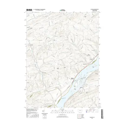
2016 Map of Dalmatia
USGS Topo · Published 2016About this map
Susquehanna River islands and riverbank settlements define this portion of central Pennsylvania along the borders of Snyder and Northumberland counties. The river corridor is anchored by Port Trevorton and Dalmatia, where the S Susquehanna Trl and rail infrastructure parallel the water. Inland, the landscape transitions into a series of agricultural valleys, including Pleasant Valley, Flint Valley, and Trout Valley, separated by prominent ridges like Fisher Ridge. Small rural communities such as Meiserville, Hoffer, and Pallas are connected by a network of local roads that follow the winding paths of North Branch Mahantango Creek and its tributaries. The map captures the enduring rural settlement patterns of the region, from the riverside ferry history at McKees Half Falls to the upland farms near Verdilla.
Find a feature on this map
38 named features on this map. Tap any name to fly to it.
Don’t see what you’re looking for? This feature index may not catch every label — zoom into the map to look around manually.
Map Details
Editions of this 2016 Dalmatia Map
This is the sole edition of this map. No revisions or reprints were ever made.
Other maps of this area

1893 · Sunbury
USGS Topo · 1:62,500

1893 · Millersburg
USGS Topo · 1:62,500

1907 · Millerstown
USGS Topo · 1:62,500

1938 · Mifflinburg
USGS Topo · 1:48,000

1943 · Millerstown
USGS Topo · 1:62,500

1943 · Millersburg
USGS Topo · 1:62,500

1943 · Sunbury
USGS Topo · 1:62,500

1943 · Mifflinburg
USGS Topo · 1:62,500
1947 · Elizabethville
USGS Topo · 1:24,000
1947 · Millersburg
USGS Topo · 1:24,000