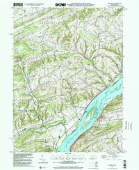
1999 Map of Dalmatia
USGS Topo · Published 2001About this map
The Susquehanna River dominates this central Pennsylvania landscape, carving through prominent terrain features like Fisher Ridge and Hooflander Mtn. Large river islands, including Herrold Island, Zelger Island, and Browns Island, are depicted along this stretch of the waterway. The settlement pattern is defined by several small villages and hamlets, with Dalmatia situated on the eastern bank and Meiserville and McKees Half Falls on the western side.
Find a feature on this map
55 named features on this map. Tap any name to fly to it.
Don’t see what you’re looking for? This feature index may not catch every label — zoom into the map to look around manually.
Map Details
Editions of this 1999 Dalmatia Map
This is the sole edition of this map. No revisions or reprints were ever made.
Other maps of this area

1893 · Sunbury
USGS Topo · 1:62,500

1893 · Millersburg
USGS Topo · 1:62,500

1907 · Millerstown
USGS Topo · 1:62,500

1938 · Mifflinburg
USGS Topo · 1:48,000

1943 · Millerstown
USGS Topo · 1:62,500

1943 · Millersburg
USGS Topo · 1:62,500

1943 · Sunbury
USGS Topo · 1:62,500

1943 · Mifflinburg
USGS Topo · 1:62,500
1947 · Elizabethville
USGS Topo · 1:24,000
1947 · Millersburg
USGS Topo · 1:24,000
Featured Places
- Chapman, PA
- Chapman Township, PA
- Port Trevorton, PA
- Lower Mahanoy Township, PA
- Upper Paxton Township, PA