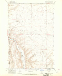
1968 Map of Dalreed Butte
USGS Topo · Published 1970About this map
Willow Creek cuts a deep valley through the high desert of the Oregon interior, creating a corridor for vital transportation infrastructure. The Union Pacific railroad tracks follow the winding path of the water, a classic example of western rail engineering utilizing natural grades through arid landscapes. On the heights above the canyon, the map records the enduring paths of the Oregon Tr and the Immigrant Road, showing how early pioneer routes were still preserved across the plateaus of Morrow and Gilliam counties in the late 1960s. The landscape is a mix of shifting Sand Dunes and prominent basalt landmarks like Dalreed Butte. Evidence of rural activity and technical utility appears in isolated features such as Schoolhouse Canyon, a remote Test Site, and a few scattered water sources like Red Well.
Find a feature on this map
14 named features on this map. Tap any name to fly to it.
Don’t see what you’re looking for? This feature index may not catch every label — zoom into the map to look around manually.
Map Details
Editions of this 1968 Dalreed Butte Map
This is the sole edition of this map. No revisions or reprints were ever made.
Other maps of this area

1906 · Blalock Island
USGS Topo · 1:125,000

1908 · Blalock Island
USGS Topo · 1:125,000

1916 · Arlington
USGS Topo · 1:125,000

1953 · Pendleton
USGS Topo · 1:250,000

1953 · The Dalles
USGS Topo · 1:250,000

1956 · The Dalles
USGS Topo · 1:250,000

1956 · Pendleton
USGS Topo · 1:250,000

1957 · The Dalles
USGS Topo · 1:250,000

1962 · Alderdale
USGS Topo · 1:24,000

1962 · Heppner Junction
USGS Topo · 1:24,000