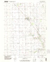
1998 Map of Dalton City
USGS Topo · Published 2003About this map
Dalton City anchors this central Illinois landscape, serving as a focal point where the agricultural grid of Dora and Milam townships meet. The map reveals a drainage pattern defined by the southward flow of Big Creek, Marrowbone Creek, and Brush Creek, which carve gentle relief into the prairie. This late 20th-century survey captures the region's enduring rural character, where small clusters like Reddy and Bland stand alongside essential local landmarks such as New Hope Ch. Genealogists will find particular value in the location of Walker Cem near the southern boundary of Marrowbone. The presence of Sewage Disposal Ponds near the main settlement reflects the modern infrastructure supporting this persistent farming community at the intersection of Macon, Moultrie, and Shelby counties.
Find a feature on this map
17 named features on this map. Tap any name to fly to it.
Don’t see what you’re looking for? This feature index may not catch every label — zoom into the map to look around manually.
Map Details
Editions of this 1998 Dalton City Map
This is the sole edition of this map. No revisions or reprints were ever made.
Other maps of this area

1929 · Decatur
USGS Topo · 1:62,500

1933 · Decatur
USGS Topo · 1:62,500

1935 · Sullivan
USGS Topo · 1:48,000

1940 · Sullivan
USGS Topo · 1:62,500

1949 · Dalton City
USGS Topo · 1:62,500

1955 · Bement
USGS Topo · 1:62,500

1958 · Decatur
USGS Topo · 1:250,000

1961 · Decatur
USGS Topo · 1:250,000

1967 · Long Creek
USGS Topo · 1:24,000

1967 · Decatur
USGS Topo · 1:24,000