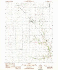
1983 Map of Dalton City
USGS Topo · Published 1983About this map
Dalton City serves as the primary hub of this Central Illinois landscape, situated at the junction of several civil townships including Mount Zion, Dora, and Milam. The town's layout is closely tied to the diagonal path of the Illinois Central Gulf railroad, which cuts through the grain-producing flatlands. Waterways like Marrowbone Creek and Big Creek drain the surrounding fields, providing the only significant relief in the topography. Genealogists will find the locations of New Hope Cem and Walker Cem valuable for tracing local family history. Smaller landmarks, such as the Bland Landing Strip and a Radio Facility, reflect the modernization of the rural economy by the early 1980s, while the settlement of Reddy remains a quiet point on the map.
Find a feature on this map
21 named features on this map. Tap any name to fly to it.
Don’t see what you’re looking for? This feature index may not catch every label — zoom into the map to look around manually.
Map Details
Editions of this 1983 Dalton City Map
This is the sole edition of this map. No revisions or reprints were ever made.
Other maps of this area

1929 · Decatur
USGS Topo · 1:62,500

1933 · Decatur
USGS Topo · 1:62,500

1935 · Sullivan
USGS Topo · 1:48,000

1940 · Sullivan
USGS Topo · 1:62,500

1949 · Dalton City
USGS Topo · 1:62,500

1955 · Bement
USGS Topo · 1:62,500

1958 · Decatur
USGS Topo · 1:250,000

1961 · Decatur
USGS Topo · 1:250,000

1967 · Long Creek
USGS Topo · 1:24,000

1967 · Decatur
USGS Topo · 1:24,000