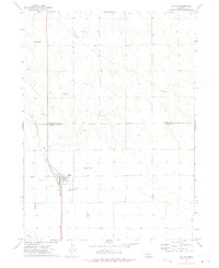
1972 Map of Dalton
USGS Topo · Published 1975About this map
Dalton serves as the focal point of this 1970s landscape, situated along the Burlington Northern railroad corridor on the high plains of the Nebraska Panhandle. The map reveals a community supported by a combination of agriculture and resource extraction, with numerous Oil Wells and several Gravel Pits scattered across the surrounding terrain. Notable local landmarks include Lookout Mound to the northwest and a lone Spring near a major Pipeline that cuts across the northern sections. For those researching local family history, the map specifically identifies both St Marys Cem and the Dalton Cem on the outskirts of the village. The boundary line between Morrill Co and Cheyenne Co bisects the northern half of the sheet, providing a clear view of the jurisdictional layout during this era.
Find a feature on this map
15 named features on this map. Tap any name to fly to it.
Don’t see what you’re looking for? This feature index may not catch every label — zoom into the map to look around manually.
Map Details
Editions of this 1972 Dalton Map
This is the sole edition of this map. No revisions or reprints were ever made.
Other maps of this area

1896 · Browns Creek
USGS Topo · 1:125,000

1898 · Camp Clarke
USGS Topo · 1:125,000

1899 · Browns Creek
USGS Topo · 1:125,000

1899 · Sidney
USGS Topo · 1:125,000

1954 · Scottsbluff
USGS Topo · 1:250,000

1958 · Scottsbluff
USGS Topo · 1:250,000

1965 · Broadwater
USGS Topo · 1:24,000

1965 · Courthouse Rock
USGS Topo · 1:24,000

1965 · Broadwater SW
USGS Topo · 1:24,000

1972 · Gurley
USGS Topo · 1:24,000