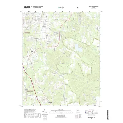
2020 Map of Dalton South
USGS Topo · Published 2020About this map
Dalton and its southern neighboring communities define this landscape where the Chattahoochee National Forest meets the developed corridors of Whitfield County. The Conasauga River winds through the central valley, flanked by distinctive terrain like Loopers Bend and the Brackett Ridges. This survey captures the region's transport network as it appeared in the late 2010s, showing the concentration of light industry and residential growth between Phelps and Carbondale. Local history is preserved through numerous family and community sites, including Keiths Mill in the northeast and several rural burial grounds such as Hopewell Cem and Tilton Community Cem. The map provides a detailed view of the infrastructure supporting the area, from the Dalton Municipal Airport to the various spans crossing the river, including Tilton Bridge and Sloan Bridge, which connect the scattered settlements of Pratersville and Tilton to the broader county road system.
Find a feature on this map
161 named features on this map. Tap any name to fly to it.
Don’t see what you’re looking for? This feature index may not catch every label — zoom into the map to look around manually.
Map Details
Editions of this 2020 Dalton South Map
This is the sole edition of this map. No revisions or reprints were ever made.
Other maps of this area

1886 · Dalton
USGS Topo · 1:125,000

1886 · Ringgold
USGS Topo · 1:125,000

1892 · Ringgold
USGS Topo · 1:125,000

1892 · Dalton
USGS Topo · 1:125,000

1897 · Dalton
USGS Topo · 1:125,000

1935 · Villanow
USGS Topo · 1:24,000

1935 · Tunnel Hill
USGS Topo · 1:24,000

1938 · Chatsworth
USGS Topo · 1:48,000

1943 · Dalton
USGS Topo · 1:62,500
1943 · Tunnel Hill
USGS Topo · 1:24,000