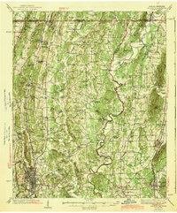
1943 Map of Dalton
USGS Topo · Published 1943About this map
Dalton and Chatsworth anchor this late 1930s landscape, illustrating the development of Whitfield and Murray counties just before the mid-century industrial shift. The map reveals a high density of rural institutions, such as Deep Spring Sch, Fullers Chapel, and the County Farm, reflecting a time when social life was organized around local schoolhouses and country churches. The Conasauga River and Coahulla Creek snake through the center, crossed by essential infrastructure like Lower Kings Bridge and Goswick Bridge. Transportation is defined by the Southern and Louisville and Nashville railroads, which parallel early road networks like the Cleveland Road. At the edge of Dalton, the presence of an Aviation Field and a Fairground indicates the city's emerging role as a regional hub for commerce and public gatherings.
Find a feature on this map
77 named features on this map. Tap any name to fly to it.
Don’t see what you’re looking for? This feature index may not catch every label — zoom into the map to look around manually.
Map Details
Editions of this 1943 Dalton Map
2 editions found

Other maps of this area

1886 · Dalton
USGS Topo · 1:125,000

1886 · Cleveland
USGS Topo · 1:125,000

1886 · Ringgold
USGS Topo · 1:125,000

1888 · Chattanooga
USGS Topo · 1:125,000

1892 · Ringgold
USGS Topo · 1:125,000

1892 · Cleveland
USGS Topo · 1:125,000

1892 · Dalton
USGS Topo · 1:125,000

1893 · Chattanooga
USGS Topo · 1:125,000

1895 · Cleveland
USGS Topo · 1:125,000

1897 · Dalton
USGS Topo · 1:125,000