
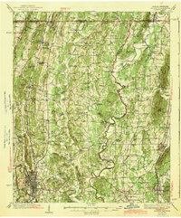
1943 Map of Dalton
USGS Topo · Published 1943About this map
The industrial and agricultural center of Dalton sits at the foot of the Blue Ridge Mountains, anchored by a dense network of textile mills and the crossing of the Southern and Louisville and Nashville railroads. This mid-century survey reveals a landscape defined by its waterways and small, tight-knit communities like Spring Place and Chatsworth. Local commerce and milling history are represented by sites such as Praters Mill and Gregorys Mill, while the Conasauga River snakes along the eastern half, providing a natural boundary between Murray and Whitfield counties.
Find a feature on this map
96 named features on this map. Tap any name to fly to it.
Don’t see what you’re looking for? This feature index may not catch every label — zoom into the map to look around manually.
Map Details
Editions of this 1943 Dalton Map
2 editions found
Other maps of this area

1886 · Dalton
USGS Topo · 1:125,000

1886 · Cleveland
USGS Topo · 1:125,000

1886 · Ringgold
USGS Topo · 1:125,000

1888 · Chattanooga
USGS Topo · 1:125,000

1892 · Ringgold
USGS Topo · 1:125,000

1892 · Cleveland
USGS Topo · 1:125,000

1892 · Dalton
USGS Topo · 1:125,000

1893 · Chattanooga
USGS Topo · 1:125,000

1895 · Cleveland
USGS Topo · 1:125,000

1897 · Dalton
USGS Topo · 1:125,000