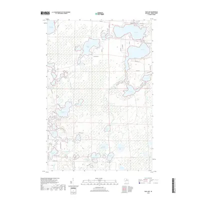
2018 Map of Dam Lake
USGS Topo · Published 2018About this map
Dam Lake and Sand Lake dominate the northeastern corner of this Oneida County landscape, where the interconnected waterways of the Northwoods define the local character. In this 2018 survey, the area around North Nokomis Lake and Paradise Lake shows a dense network of local roads such as Silver Shore Ln and W Nokomis Lake Dr, reflecting decades of recreational development along these shorelines. The central and southern portions of the map are a labyrinth of wetlands and smaller basins, including the family-named Jenny Barnes Lake and Tom Doyle Lake. Numerous drainages like Sugar Camp Creek and Muskellunge Creek weave through the marshy terrain, connecting prominent bodies like Muskellunge Lake to the broader regional watershed. This modern snapshot preserves the names of small, secluded waters such as Oatmeal Lake and Tim Lynn Lake that remain central to the area's geography.
Find a feature on this map
71 named features on this map. Tap any name to fly to it.
Don’t see what you’re looking for? This feature index may not catch every label — zoom into the map to look around manually.
Map Details
Editions of this 2018 Dam Lake Map
This is the sole edition of this map. No revisions or reprints were ever made.
Other maps of this area

1930 · Robbins
USGS Topo · 1:48,000

1938 · Minocqua
USGS Topo · 1:48,000

1938 · Robbins
USGS Topo · 1:48,000

1939 · Cassian
USGS Topo · 1:48,000

1940 · Rhinelander
USGS Topo · 1:48,000

1942 · Cassian
USGS Topo · 1:48,000

1945 · Robbins
USGS Topo · 1:48,000

1946 · Minocqua
USGS Topo · 1:48,000

1949 · Rhinelander
USGS Topo · 1:48,000

1949 · Minocqua
USGS Topo · 1:48,000