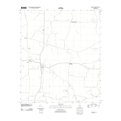
2011 Map of Damascus
USGS Topo · Published 2011About this map
Damascus and its predecessor, Old Damascus, serve as the primary hubs in this agricultural pocket of Early County. The landscape is defined by a dense network of country roads and several rural communities, including Douglasville, Crossroads, and Douglass Crossroads. For genealogists, the map is remarkably rich in family-named burial sites, such as Billings Cemetery, Pullen Cemetery, and Sheffield Cemetery, which are scattered throughout the farmlands. Industrial and utilitarian markers include the Rowena Lookout Tower and the Damascus Post Office, indicating the local infrastructure of the era. The terrain is drained by numerous watercourses, with Big Cypress Creek and Long Branch meandering through the plots, while larger drainage features like Big Drain move water away from the established settlements and rural homesteads.
Find a feature on this map
57 named features on this map. Tap any name to fly to it.
Don’t see what you’re looking for? This feature index may not catch every label — zoom into the map to look around manually.
Map Details
Editions of this 2011 Damascus Map
This is the sole edition of this map. No revisions or reprints were ever made.
Other maps of this area

1953 · Dothan
USGS Topo · 1:250,000

1954 · Dothan
USGS Topo · 1:250,000

1955 · Dothan
USGS Topo · 1:250,000

1973 · Bancroft
USGS Topo · 1:24,000

1973 · Hentown
USGS Topo · 1:24,000

1974 · Donalsonville NE
USGS Topo · 1:24,000

1974 · Damascus
USGS Topo · 1:24,000

1974 · Arlington
USGS Topo · 1:24,000

1974 · Cooktown
USGS Topo · 1:24,000
1974 · Colquitt
USGS Topo · 1:24,000